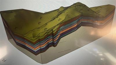
Geothecnical Invastigation And Parameters
Published 3/2023
MP4 | Video: h264, 1280x720 | Audio: AAC, 44.1 KHz
Language: English | Size: 938.59 MB | Duration: 1h 14m
Geothecnical Survey and Impleting Data in GIS
What you'll learn
Introduction to Geotechnics: types of investigations and parameters
Geothecnical Survey ; estimate parameters
Implementing Geothecnical Data in GIS
Prepare Resume and Report for Client
Requirements
Basic Knowledge of Geology
Understand Coordinate Projection
Principle of Physics
Description
I invite you to take this course to learn a different approach to the geotechnical sector. The usual roundup of investigation methods will not be presented, but the course will try to analyze the different types of geotechnical investigations by providing a very direct approach, trying to connect them directly to practical use. Therefore we will try to focus on a one-to-one relationship between the investigations that can be performed in the field - the parameters - the geotechnical problems to be solved. We will try to provide a very practical and direct cut, which can facilitate the learners in introducing the subject. In the first part the direct investigations on site and the types of parameters that can be obtained will be analyzed, then the direct investigations with sampling - the laboratory tests, the type of parameters that can be obtained, which tests to carry out, which parameters can be obtained and in which cases to use them (some case history).The last part will deal with how to import and implement geotechnical data obtained from direct surveys and laboratory tests in a GIS environment; also to be able to view them spatially, geo-reference them, view the parameters at different depths to create a geotechnical model.
Overview
Section 1: Introduction to Geotecnics
Lecture 1 Introduction to Site Investigastion
Lecture 2 Probe testing and Samples : laboratory investigastions
Lecture 3 Correct use of Geotecnics parameter
Section 2: Implementing in GIS Geothecnical site investigation and Create Report
Lecture 4 Implementing Geotecnical Survey in GIS software
Lecture 5 Create Report for client
Geology Student,Professional Degree,Joung Engeneering
rapidgator.net:
uploadgig.com:Kod:https://rapidgator.net/file/e739d88277af258e3c59b7d97ea330d9/bomtj.Geothecnical.Invastigation.And.Parameters.rar.html
nitroflare.com:Kod:https://uploadgig.com/file/download/b938d9847D064532/bomtj.Geothecnical.Invastigation.And.Parameters.rar
1dl.net:Kod:https://nitroflare.com/view/89CA614087E98AE/bomtj.Geothecnical.Invastigation.And.Parameters.rar
Kod:https://1dl.net/23p6s4rdt68l/bomtj.Geothecnical.Invastigation.And.Parameters.rar
1 sonuçtan 1 ile 1 arası
-
11.03.2023 #1Üye


- Üyelik tarihi
- 20.08.2016
- Mesajlar
- 144.947
- Konular
- 0
- Bölümü
- Bilgisayar
- Cinsiyet
- Kadın
- Tecrübe Puanı
- 153
Geothecnical Invastigation And Parameters
Konu Bilgileri
Users Browsing this Thread
Şu an 1 kullanıcı var. (0 üye ve 1 konuk)


 LinkBack URL
 About LinkBacks


 Alıntı
Konuyu Favori Sayfanıza Ekleyin