(x86/x64) English | File size: (21.7/22.5) MB
GEOPoint is an easy to use satellite antenna pointing calculator, for geostationary communications satellites.
It calculates the azimuth and elevation pointing angles from a given location on the earth towards a specified geostationary satellite. The program also calculates polarisation tilt angles, estimates dates and s of annual sun-outage events, calculates antenna G/T, EIRP and frequency stability, and estimates path-loss and rain-attenuation based on ITU-R climate models. As used by Hausfeld Consulting for satellite communications planning. an easy to use dialog-style user interface for data entry and calculation;
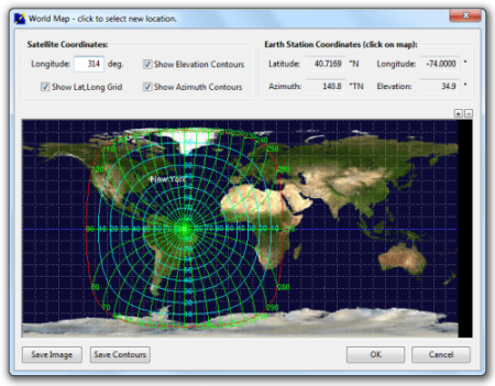
entry of earth station location coordinates directly, or by clicking on a world map;
select earth station location from a built-in list of world major cities;
display of satellite azimuth and elevation contours on the world map to aid in site selection;
entry of latitude and loude coordinates in d,m,s format, or as decimal degrees;
entry of coordinates in Australian AMG coordinates and automatic conversion to latitude, loude;
calculation of pointing angles to a specified satellite for common types of antenna mount;
display of azimuth pointing angles relative to True North, and relative to local magnetic north;
estimation of antenna movement limits for inclined orbit satellites;
calculation of polarisation tilt angle, loop-back path delay, and required antenna tracking speeds;
estimation of the peak dates and s for sun-interference on the receive link.
Output of a summary report in PDF or HTML format.
ability to zoom the world map one level for more accurate site selection;
ability to save the current map image to file.
ability to save azimuth and elevation contours to a KML file for viewing in Google Earth.
estimation of site altitude from ITU-R world topography model;
select earth station location from a user supplied file containing a list of sites;
view and save a diagram of the GEO Arc visible from the site;
labelling of individual satellites and plotting local horizon and antenna movement limits;
plotting of satellite locations from Norad two-line element or Intelsat ephemeris format orbit data;
display of ITU-R Climate Model data for the specified earth station location;
estimate antenna G/T from user inputs of antenna parameters and frequency;
calculate path loss between the earth station and satellite at a specified frequency using ITU-R propagation models;
estimate the impact of satellite motion on EIRP and frequency stability;
output a batch report of pointing angles from the site, for a list of user selected satellites;
output a detailed report of sun interference dates and s for given receive antenna parameters;
output a detailed report of rain attenuation loss for a range of frequencies and link availability;
output a batch summary report for a list of earth station sites.
Updates: official site does not provide any info about changes in this version.
DOWNLOAD
uploadgig
rapidgatorKod:https://uploadgig.com/file/download/08E19Bbe568da8d8/mYKcq5nW_.GEOPoint_4.rar https://uploadgig.com/file/download/b725c8a75405536F/mYKcq5nW_.GEOPoint_4_.rar
nitroflareKod:https://rapidgator.net/file/eb4229b7cd5427dadb316ca911ca8f87/mYKcq5nW_.GEOPoint_4.rar https://rapidgator.net/file/3104e72e2777caa117cc8ab70664c157/mYKcq5nW_.GEOPoint_4_.rar
Kod:http://nitroflare.com/view/5AAE8C84739CE5A/mYKcq5nW_.GEOPoint_4.rar http://nitroflare.com/view/4E040EC0934986B/mYKcq5nW_.GEOPoint_4_.rar
1 sonuçtan 1 ile 1 arası
-
21.02.2020 #1
Gunamoi GEOPoint 4.3 (x86/x64)
Konu Bilgileri
Users Browsing this Thread
Şu an 1 kullanıcı var. (0 üye ve 1 konuk)


 LinkBack URL
 About LinkBacks


 Alıntı
Konuyu Favori Sayfanıza Ekleyin